What is the Geographic Information System Market Size?
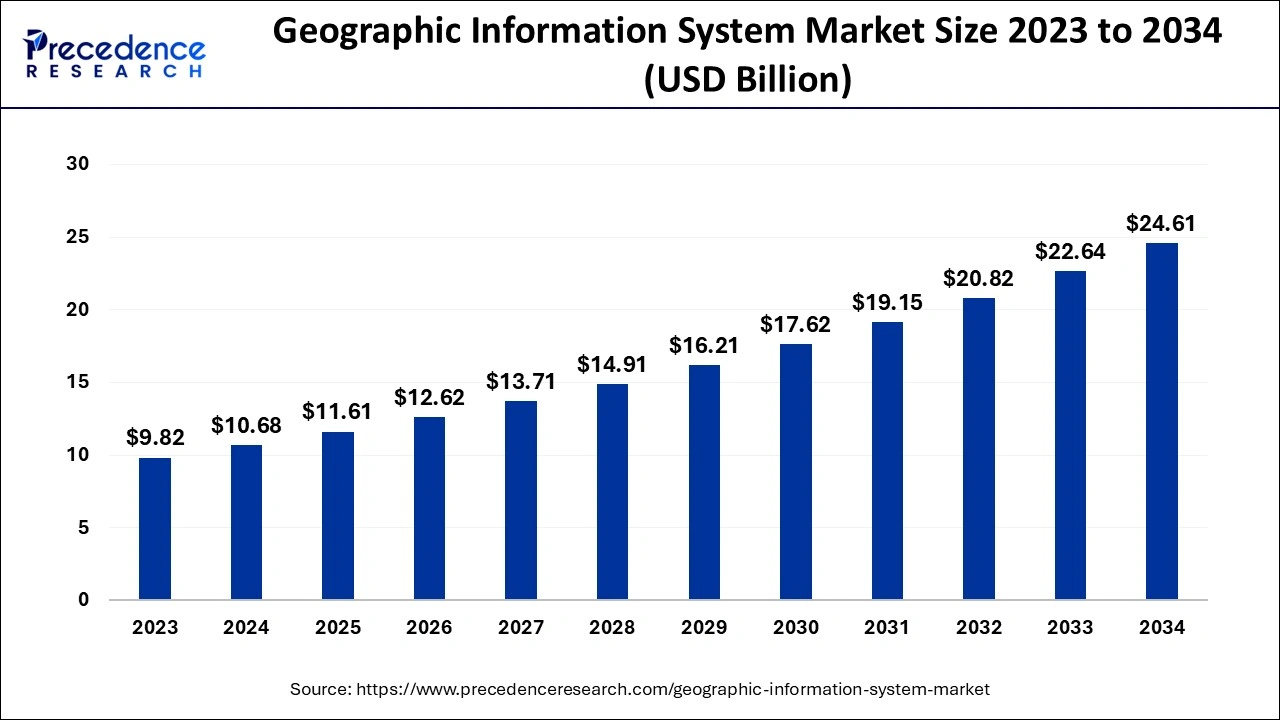
The global geographic information system market size is calculated at USD 11.61 billion in 2025 and is predicted to increase from USD 12.62 billion in 2026 to approximately USD 26.48 billion by 2035, expanding at a CAGR of 8.59% from 2026 to 2035. Rising investments in urban infrastructure, such as smart city projects, are key factors driving market growth. Also, increasing applications of the geographic information system (GIS) in different sectors, along with the rising health concerns globally, can fuel market growth shortly.

Geographic Information System Market Key Takeaways
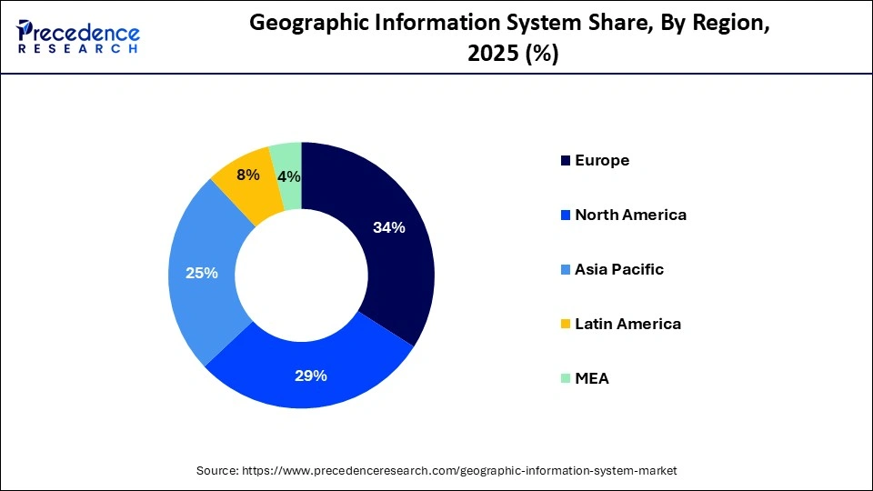
- Europe led the geographic information system market with the largest market share of 34% in 2025.
- The Asia Pacific market is anticipated to grow at the fastest rate over the forecast period.
- By component, the services segment contributed the biggest market share of 55% in 2025.
- By usage, the navigation segment accounted for the highest market share of 48% in 2025.
- By usage, the surveying segment is anticipated to grow at the fastest rate during the forecast period.
- By devices, the desktop segment generated the biggest market share of 61% in 2025.
- By devices, the mobile segment is anticipated to grow at the fastest rate over the projected period.
- By vertical, the utilities segment recorded more than 18% of market share in 2025.
- By vertical, the construction segment is estimated to grow at the fastest rate over the studied period.
Role of AI in the Geographic Information System Market
The integration of artificial intelligence (AI) with geographic information systems is expected to create new opportunities for the market. Key players are integrating artificial intelligence (AI) because of technological advancements. Furthermore, the utilization of geospatial artificial intelligence, which deploys AI to collect data from geographical data sets, has aided governments in designing smart cities and urban infrastructure.
- In October 2024, Esri, the leading geographic information system (GIS) technology and location intelligence, together with Autodesk, Inc., a world leader in building information modeling, are improving their strategic alliance. This latest integration introduces Esri's authoritative geospatial reference data into Autodesk Forma to change early design and planning stages for AECO professionals.
How is the overview specifying the key potential of the Geographic Information System Market?
A Geographic Information System (GIS) is a computer that generates a system for managing, storing, collecting, analyzing, and visualizing geographic data. It also combines software, technology, and other data to guide users in understanding geographical correlations GIS provides an extensive range of applications in various sectors, like in urban planning, it aids in land use management, decreasing adverse impacts on the environment while promoting growth.
Geographic Information System Market Growth Factors
- The increasing demand for accurate forecasts of natural calamities is expected to boost market growth shortly.
- The adoption of GIS in the military and defense sectors can propel market growth further.
- The growing use of GIS technology in precision farming and soil mapping will likely contribute to market growth.
Geographic Information System Market Outlook
The GIS start-up is extensive and vibrant, with the existing companies and smart minds accelerating satellite imagery, cloud computing, and AI for applications, empowering start-ups to experiment and grow in the vast GIS market throughout the diverse industries. The major leading international start-ups in this market are following the top trends of the market like real-time data analysis, specialised applications, cloud computing and SaaS.
The GIS market takes off its potency and lands in the technological advancement speciality to speed the growth in the market. The demand for urban planning and smart cities has accelerated the market with the heavy government investment, driving the best of GIS solutions. GIS is important for infrastructure management (utilities, roads), environmental impact evaluation and site selection.
Market Scope
| Report Coverage | Details |
| Market Size by 2035 | USD 26.48 Billion |
| Market Size in 2025 | USD 11.61 Billion |
| Market Size in 2026 | USD 12.62 Billion |
| Market Growth Rate from 2025 to 2034 | CAGR of 8.71% |
| Largest Market | Europe |
| Base Year | 2025 |
| Forecast Period | 2026 to 2035 |
| Segments Covered | Component, Usage, Devices, Vertical, and Regions |
| Regions Covered | North America, Europe, Asia-Pacific, Latin America and Middle East & Africa |
Market Dynamics
Driver
Increasing demand for GIS in disaster management
Environmental change-related natural calamities are increasing frequently stimulating the adoption of GIS for emergency response and risk assessment. Additionally, GIS technology is crucial for analyzing climatic data and predicting potential dangers along with controlling disaster response activities. The combination of Internet of Things technology with GIS can further promote the use of this system in disaster management.
- In January 2024, Tourism Minister P.A. Mohamed Riyas launched Kozhikode Corporation's Geographic Information System (GIS)-based mapping project of the Kozhikode Corporation for disaster management, which is operating a drone used for the mapping process.
Restraint
Inconsistent data quality
The accuracy and dependability of the geographical data processed by GIS are important to its efficacy. Enterprises can struggle with improperly arranged data, which can result in incorrect decisions and assessments. Moreover, this problem is caused by various factors like gaps in data-gathering methods and less uniformity among datasets that affect utilization and integration.
Opportunity
Rising demand for cloud-based GIS solutions
Cloud technology offers flexibility, scalability, and cost-effectiveness, allowing businesses to access GIS applications from remote locations while reducing the requirement for wide on-premises infrastructure. Furthermore, the conversion to cloud-based systems stimulates real-time data cooperation and exchange across stakeholders, which is crucial for strong decision-making. Which in turn can create geographic information system market opportunities in the future.
- In July 2023, AECOM, the world's leading infrastructure consulting firm, announced that Digital AECOMs PlanEngage is now powered by Esri ArcGIS Online software. Esri is the global market leader in geographic information system (GIS) software. The PlanEngage platform enables project teams to collaboratively create, edit, and publish highly visual and interactive information.
Geographic Information SystemMarket Segment Insights
Component Insights
The services segment led the geographic information system market in 2025 and is anticipated to grow at the fastest rate over the forecast period. The dominance and growth of the segment can be attributed to the rising adoption of GIS systems and other activities by market players to grow across the globe. Additionally, the increasing partnerships among the top companies in the market to enhance the GIS system can further contribute to the segment expansion.
Usage Insights
The navigation segment dominated the geographic information system market in 2025. The dominance of the segment can be linked to the features offered by the GIS system, such as analyzing spatial data, enabling users to assess patterns, visualize routes, and optimize travel times. The GIS systems can gather real-time data related to the routes taken, locations, and fuel consumption of a specific vehicle. It can further help organizations to adjust routes and analyze traffic patterns.
- In September 2024, alertMedia, the world's top threat intelligence, emergency communication, and travel risk management provider, unveiled the launch of Visual Intelligence, a new offering providing powerful mapping and geospatial analysis tools that maximize visibility into emergencies and other critical events.
The surveying segment is anticipated to grow at the fastest rate in the geographic information system market during the forecast period. The growth of the segment can be driven by the increasing use of surveyors in many industries. Surveyors also utilize different kinds of tools to process and deliver data accurately. However, the growing government collaborations with various surveyors across the globe aim at validating and developing GIS-based land acquisition plans can drive the segment's growth in the market.
- In August 2024, The Greater Hyderabad Municipal Corporation (GHMC) conducted an Integrated Geographic Information System (GIS) survey to map every property and utility within the city jurisdiction with precision.
Devices Insights
In 2025, the desktop segment dominated the geographic information system market by holding the largest market share. This is because Desktop applications enable end users to leverage innovative tools for data analysis, create detailed maps, and perform intricate spatial analyses. These features are primarily available in the desktop versions, which fuel their demand.
The mobile segment is anticipated to grow at the fastest rate in the geographic information system market over the projected period. The growth of the segment can be linked to the increasing development of innovative mobile features and applications for use in different industries. Also, the increase in demand for location-based services in a wide range of sectors, such as transportation, urban planning, and environmental management, is boosting market growth shortly.
Vertical Insights
The utilities segment led the geographic information system market in 2025. The dominance of the segment can be driven by growing urbanization across the world and the increase in demand for innovative sewage, water, telephone lines, and power lines. Furthermore, the utility segment offers critical visualization capabilities that enable keen analysis and firm decision-making.
The construction segment is estimated to grow at the fastest rate over the studied period. This is due to the sector has embraced GIS for its integral role in supplies, resource management, and personnel. Construction companies use GIS to stimulate resource allocation which results in cost effectiveness and more catered project schedules. Additionally, the segment is ready to play an important role in fuelling the expansion of the Geographic Information System market.
- In July 2024, Trimble announced the expansion of their long-standing strategic partnership with Esri to improve collaboration in geographic information system (GIS) software, location intelligence, and mapping.
Geographic Information System Market Regional Insights
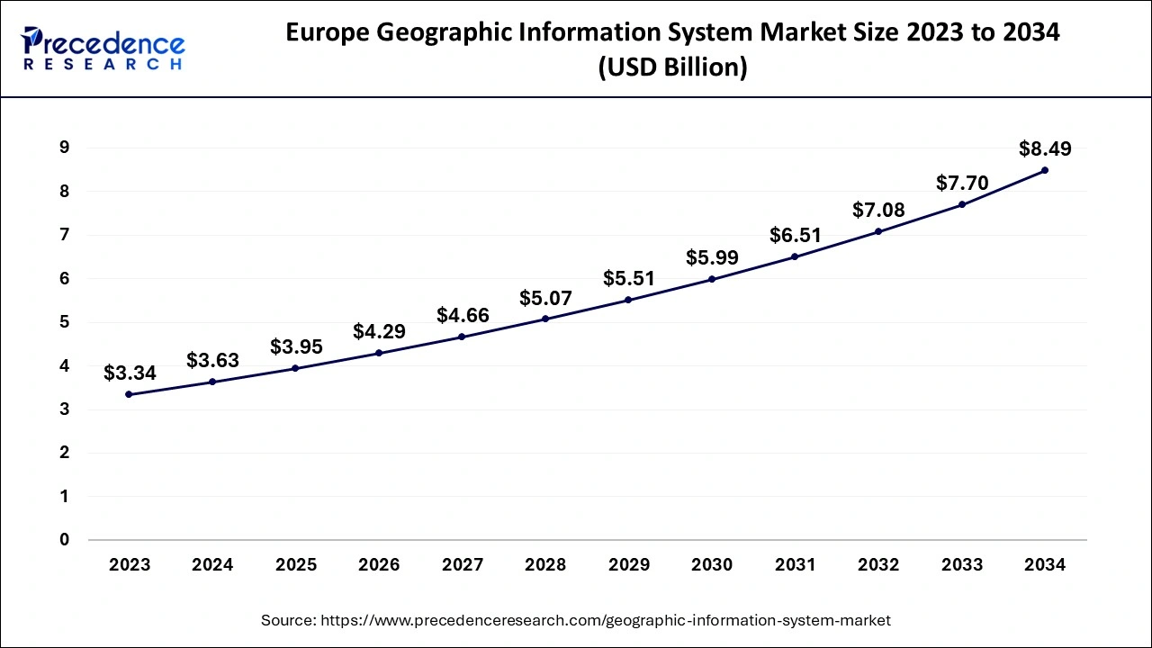
The Europe geographic information system market size is exhibited at USD 3.95 billion in 2025 and is predicted to be worth around USD 9.17 billion by 2034, growing at a CAGR of 8.87% from 2026 to 2035.

North America dominated the geographic information system market in 2025. The dominance of the segment can be attributed to the increasing adoption of advanced technology and the strong presence of market players. Furthermore, the region's embrace of advanced technologies has propelled advancements in real-time data processing and spatial analysis. Hence North America stands out as a leading market for GIS in the world.
The Asia Pacific market is anticipated to grow at the fastest rate over the forecast period. The growth of the region can be credited to the regions undergoing urban growth due to the presence of developing economies like India and China. Moreover, technological developments in the region and the rising use of GIs in resource management and urban development plans are the key factors propelling the region's geographic information system market growth.

- In July 2024, the Rajasthan Centre of Advanced Technology (R-CAT), a beacon of innovation and knowledge, and Esri India, the top provider of (GIS) software and solutions, signed a Memorandum of Understanding (MoU) to provide innovative learning opportunities for GIS technology to the youth. R-CAT is on a mission to uplift the potential of students and young professionals
- In September 2024, Esri India, the country's top location intelligence software and solutions provider, announced the availability of ĎIndo ArcGIS Business Analyst,' a location intelligence solution suite created to aid government organizations in enabling data-driven smart decisions.
Europe is a center of innovation in this market, highly characterised by the robust sustainable development goals, unification of popular reliant technologies such as digital twins, earth observation data and AI, also including digital sovereignty as a plus point for the region to rule the market. The popular smart infrastructure and initiatives like INSPIRE, Copernicus Programme, and GISCO are supporting innovation in the market. Whereas applications and tech integrations have stimulated the growth of the market.
The region is elaborating the excellence in GIS via prominent academic growth, practical applications and robust regional partnership in the urban planning, environmental monitoring and sustainable establishment. The region has paced way too far in establishing spatial data infrastructure (SDI). The most famous example is GeoSUR, which was a partnered initiative by Caribbean spatial data producers and Latin Americans.
Geographic Information System Market Value Chain Analysis
The integration of solved apt geospatial data with AI-powered frameworks, IoT and big data is beneficial for making location-centric decision-making and bolstering automation throughout the value chain. The tech has long resolved many major issues, discarding any speculations, triggering the growth of the GIS market.
The GIS marketís primary activities are operations, inbound logistics, services, outbound logistics, marketing, and sales. Whereas, HRM, technology development, firm infrastructure and procurement are the supportive activities stimulating the growth of the market. The analysis is best suited to the stages of operations in the market.
Establishing tools and methodologies to professionally examine the value added and economic impact of relevant technologies and geographic information within particular concerned sectors. For instance geomatic sector is a wide range of disciplinary that involves GIS as a major technology for evaluating, presenting, storing, processing and collecting geospatial data.
Geographic Information System Market Companies

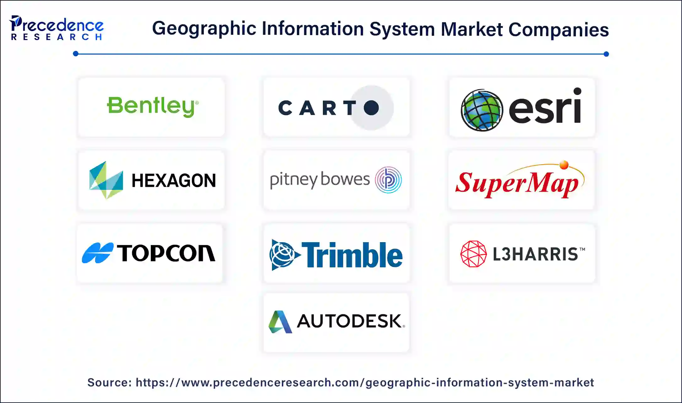
- Autodesk Inc.
- Bentley Systems, Incorporated
- CARTO
- Environmental Systems Research Institute, Inc.
- Hexagon AB
- Pitney Bowes Inc.
- SuperMap Software Co., Ltd.
- TOPCON CORPORATION
- Trimble Inc.
- L3Harris Technologies, Inc.
Recent Developments
- In May 2024, GIS Solutions, Inc. provides enterprise GIS technology and services, including cloud-based database design and GIS application development. NV5 Global, Inc. announced the acquisition of the company.
- In April 2023, Trimble Inc. introduced the Trimble Unity AMS solution, an electric-based platform with a GIS focus designed to manage asset infrastructure lifecycles.
- In June 2022, Bentley Acceleration Initiatives, Bentley Systems' internal incubator for strategic investment, introduced Construct Helix. It is specifically developed to digitize construction project flows by delivering SaaS solutions that enable a connected data environment.'
- In June 2022, Hexagon, a manufacturing behemoth and multibillion-dollar pioneer in combining sensor, software, and digital reality solutions, funded start-ups to enhance efficiency and ESG. The Hexagon Manufacturing Intelligence Division acknowledged SmartParts and RIIICO.
Segments Covered in The Report
By Component
- Hardware
- Software
- Services
By Usage
- Surveying
- Mapping
- Navigation
By Devices
- Desktop
- Mobile
By Vertical
- Utilities
- Construction
- Aerospace and Defense
- Transportation and Logistics
- Agriculture
- Mining & Geology
- Oil & Gas
- Government
- Others
By Geography
- North America
- Asia Pacific
- Europe
- Latin America
- Middle East and Africa
 Get a Sample
 Table Of Content