
Ground Penetrating Radar Market Trends, Companies, Market Size, Competitive Landscape, and Growth Forecast
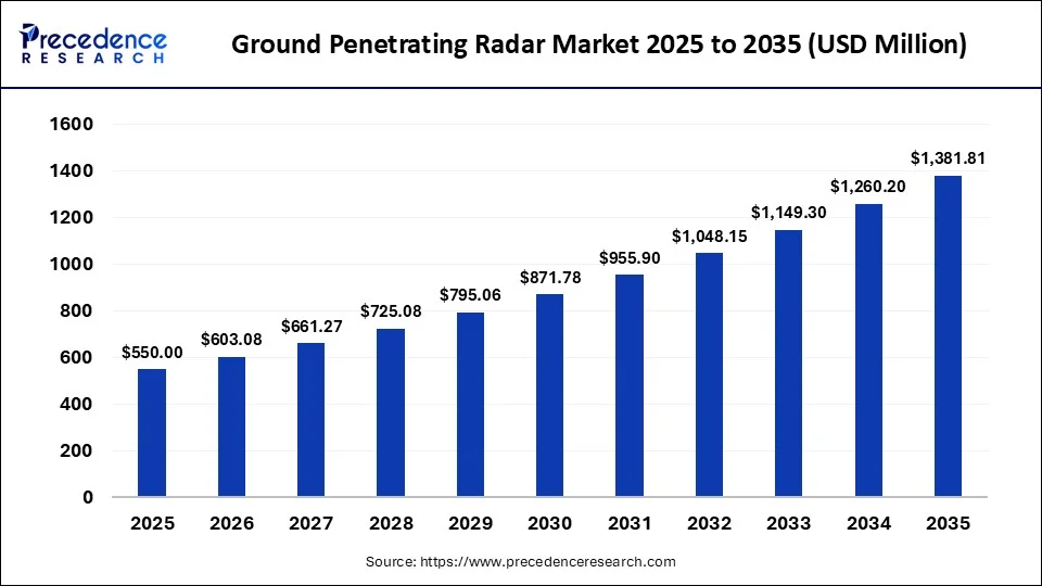
According to semiconductor and electronics specialist Laxmi Narayan, the ground penetrating radar market is valued at USD 603.08 million in 2026 and is forecast to reach USD 1,381.81 million by 2035, reflecting a CAGR of 9.65%. Leading ground penetrating radar market companies, including Radiodetection Ltd., Pipehawk Plc, Israel Aerospace Industries Ltd., are strengthening their presence across key segments such as product type, frequency range, component, application, end user, survey method, distribution channel, region.
Source: https://www.precedenceresearch.com/ground-penetrating-radar-market
 Get a Sample
 Table Of Content


Ground Penetrating Radar Market Size and Forecast 2026 to 2035
The global ground penetrating radar market size is predicted to increase from USD 603.08 million in 2026 to approximately USD 1,381.81 million by 2035, expanding at a CAGR of 9.65% from 2026 to 2035.
Key Takeaways
- By product type, the cart-based ground penetrating radar segment contributed the highest market share of 36% in 2026.
- By product type, the drone-mounted ground penetrating radar segment held 8% of market share and is expected to grow at the fastest CAGR of 17.4% between 2026 and 2035.
- By application, the utility detection segment held a major market share of 27% in 2026.
- By application, the concrete inspection segment held 12% of market share and is expected to grow at the rapid CAGR of 11.8% between 2026 and 2035.
Executive Summary
The ground penetrating radar (GPR) market is expanding as governments and infrastructure operators increasingly use non-destructive methods to investigate subsurface conditions. The most common use is to detect utilities rather than other uses. Due to the growing amount of damage to the ground beneath pedestrian excavation activities. Police officers and officers of transportation are increasingly adopting inspections as a use case. The use of GPR is growing among engineering companies. Because it helps them minimize the risk of excavation and manage assets under the ground better.
In January 2026, Hubo Cai and Yuxi Zhang of Purdue University made progress and disclosed a patent-pending approach in Advanced Engineering Informatics. That increases the accuracy of pipe location. They are squarely attacking a very expensive problem in the industry. The lack of accurate location information for most of the utility strikes reported in the United States.
This technological surge helps drive innovation of the sector as a whole. An increasing number of locations, subsurface soil and snow layers are now mapped with greater accuracy by using GPR. Drone-mounted GPR systems can survey areas that are difficult, hazardous, or inefficient to access using conventional ground-based systems. Add the relevant primary SINTEF, NGI, or Norwegian Public Roads Administration source supporting the 2026 drone-based GPR testing claim. The drones are fitted with cameras, magnetometers, and radar, and some are now powered by hydrogen-cell batteries. This enables them to operate for lengthy periods of time. On the other hand, a newer industry newcomer called Bird's View uses GPR and AI to provide automated detection of rebar in reinforced concrete. Reducing the need for destructive testing methods.
Integration has replaced hardware as a focus for investment opportunities. Various developments, such as smart city initiatives, BIM workflows, and geospatial intelligence platforms, are bringing GPR data into the wider scope of digital systems. ASTM D6432-19 still holds true to its previous use of supporting and standardizing subsurface investigation practices. Making it a consistent user for engineers' technical benchmarks. Field teams have increasingly complex tasks that are being aided by the use of multi-channel systems and cloud-based analytics. Infrastructure owners strive to create digital twins of their underground networks. GPR is becoming more of a major feature of existing asset management platforms. This is poised to go head-to-head with other OEMs, software developers, and specialized service providers in the coming years.
Market Size and Growth Outlook
Momentum is building in underground asset management. And the demand for GPR is entering a new phase of growth. The rehabilitation of infrastructure programs is still ongoing in North America, Europe, and the Asia Pacific region. Governments are assigning budget items for non-destructive inspection tools to greater total amounts of transportation budgets. The demand for portable systems is persistent. The aging pipeline systems have been installed in some parts of the world, such as Africa, and are now in need of being replaced. This trend goes beyond keeping the roads in great shape.
Agriculture is rapidly becoming an unexpected growth space as the year 2026 approaches. Precision farming operations are incorporating GPR for non-invasive soil analysis, moisture mapping, and Root Zone assessment. Research from Farmonaut shows that more than 60% of advanced agricultural projects currently being planned for the year 2026 will have some form of ground-penetrating radar. This transformation of vendors' priorities in product development. Caused by their diversification in construction, mining, defense, and agriculture, is driving several changes in the industry. This diversification across construction, mining, defense, and agriculture is bringing several changes in the product development priority areas of vendors. It also lays the groundwork for how to move forward, and which technologies and applications are taking the lead in market growth direction.
Executive Business Highlights
Handheld systems are still the most readily available and popular GPR product type. Their mobility makes them ideal for municipal, utility contractors and emergency response teams in tight urban environments. Large-area surveys such as airport runways and highways are still performed with cart-based and vehicle-mounted systems. Over thirty current major relocation/modernisation projects for airports involve runway and pavement assessment with GPR. Unit volume is not a signal of a heavy focus on innovation. The category may be the last place where innovation will be born.
The applications with the highest number of installations are detection and transportation infrastructure in the utility sector. The maintenance of roads alone consumes major GPR use. Infrastructure investment remains high in North America at an early stage of government approval, continuing to support the region. On the other hand, the rapidly domestic growth in Asia Pacific, with railway modernization and metros expanding in the Chinese and Indian markets. The focus of the commercial opportunity for providers has now narrowed from selling hardware and is more about service integration than it is about hardware.
Strategic Insights for Decision Makers
The report provides strategic insights that support business decisions. GPR manufacturers must focus on software and AI enhancements over mere hardware upgrades. Encouraging examples are Screening Eagle and its Proceq GP8000 concrete scanner. These are able to rapidly provide reports that are clear and easy to understand. Adopt real-time tools, not pre-dig only planning tools, by utility providers and construction companies. GPRS showed this development by diversifying to high-speed 3D GPR arrays that gather utility data at highway speed. Its acquisition of 2-D As-Built Floor Plans in 2024 also demonstrates in which direction a company's competitive edge will increasingly lie by integrating documentation, no longer only scanning.
Spending on defense modernization and border security ought to be closely monitored by investors in the next decade. The consistent increase in Chemring's business around mine detection and tunnel identification demonstrates a long-run and low cyclical demand in defense. Furthermore, as new AI-interpretation standards establish themselves, this compliance exercise will turn into the next priority for planning in the sector.
Executive Opportunity Snapshot
As AI Innovations for Subsurface Imaging technologies become more widely adopted, artificial intelligence is enhancing the ability to detect anomalies, interpret data automatically, and make more accurate survey measurements than ever with ground penetrating radar.
Increased road, rail and airport maintenance programs are propelling increasing usage of GPR in the areas of pavement evaluation, structural assessment and asset lifecycle management.
Market Overview
Market Definition
GPR is a technique that aims to image buried structures by using electromagnetic pulses. A transmitter emits waves in the form of radar to soil, concrete, or rock. Reflected signals bounce back at object boundaries. These are under the ground surface or buried objects. These reflections are then transformed back into pictures of pipes, rebar, voids, or geological layers by systems.
The range of frequency is one of the most important characteristics in determining the range of a system's application. Deeper penetration equals loss of image resolution at lower frequencies. Frequencies above 1,000MHz perform effectively for concrete scanning and bridge deck inspection. This compromise between depth and clarity is implicit in virtually all buying decisions buyers make. This often brings to mind the question of how deep this report went.
Scope of the Study
In this study, GPR hardware, software, and services in the construction, utilities, transportation, mining, defense, archaeology, and agriculture industry are included. Geographic coverage includes North America, Europe, Asia Pacific, Latin America, and the Middle East & Africa. Forecast assumptions include support for infrastructure rehabilitation cycles, defense modernization budgets, and adoption of precision agriculture until 2035.
Product segmentation is based on product type, application, end user industry, and frequency band. Each of these types of systems is analysed separately, such as handheld, cart based, vehicle mounted and airborne or drone mounted. This is an ideal segmentation structure to capture that sort of platform diversification.
Studies also separate software and hardware categorization from each other, considering that the software layer evolves much quicker. In addition to the desktop software suites. There are also cloud-processing tools, AI-supported interpretation service engines, and mobile-compatible platforms. This software layer has truly become indispensable. They acted as the first Platinum level sponsor of the GPR2026 conference in Newcastle. Regional demarcations in the present study correspond to the usual demarcation areas for infrastructure investments. Thus facilitating comparison between sections. The software focus continues into the evolution of the technology over the last few years.
Evolution of Ground Penetrating Radar Technology
Only specialists could interpret, by eye, the results of the GPR system. It was time consuming, sometimes incorrect, and limited to a few trained analysts. Deep learning has been indirectly influencing that relationship. However, it is beginning to alter the equation. The AI research team at Screening Eagle has developed a computer-vision pipeline. That can automatically segment GPR images and mark the detection of underground objects without human intervention.
Drone integration is the next big step for advancement. The deployment of UAVs is being expanded into other areas such as humanitarian demining, survey of tunnels, and areas that are too dangerous for foot-based troops to operate in. Independent startups are also starting intrades here, including those such as TerraScan AI. They provide cloud-based object detection that can run on a host of hardware brands during its early access in 2026. That real-world application sets up the broader question of why this technology matters so much to modern infrastructure in the first place.
Importance of Ground Penetrating Radar in Modern Infrastructure
Underground utility strikes are a non-stop hazard on a job site that can cost a lot to avoid. Strike avoidance is a priority for workers to avoid service disruptions and maintain construction programs. GPR's increasing adoption on almost all major excavation projects is warranted by a single role: that of safety. A second important application on the horizon is a structural assessment, which is becoming increasingly necessary.
Market Size Analysis
Historical Market Performance
The technology of GPR was originally designed for military use. It is used to detect mines and weapons caches in the ground. The technology was quickly picked up by archaeology. These are already famous methods that are making use of it to find the location of structures before they are destroyed. On the other hand, governments stepped up investment, especially in the transportation and defense sectors. Many dual-use radar technologies became widely adopted in civilian infrastructure usage. Owing to the result of the U.S. military's initial research and development in the field of subsurface detection.
Current Market Size (2026)
Construction and utility detection are the top uses for GPR. In the 2026 report from ASCE, U.S. bridges were awarded a C grade and drinking water earned a C-minus grade. Both of which rely on a significant amount of non-destructive subsurface exams. Roads had enjoyed an upgrade in the same report, going from a D to D+. Inspection and mapping activity is key to each of these grade changes. These grades have a direct correlation to the role of GPR.
Forecast Market Outlook (2026-2035)
Forecasted growth to 2035 is largely dependent on a continued commitment in federal investment in infrastructure beyond the current authorization period. ASCE has celebrated the benefits of IIJA. The benefits are still very much dependent on the expiration of funding authorizations from the IIJA law in 2026. The organization concludes that continuing to invest at this or higher level will be needed to maintain improving infrastructure conditions. The demand for GPRs follows that funding trend in transportation, water, and in energy.
Market Growth Scenario Analysis
The best scenario hopes that the federal government will continue to dedicate infrastructure budget. Different enterprises have different levels of acceptance of AI. The recent trend of uptake around plants, led by companies such as Screening Eagle or Hexagon, is not expected to boom immediately. Growth patterns across regions remain largely similar to those seen today, with North America and Asia Pacific emerging as the main force of adoption.
Ground Penetrating Radar Industry Ecosystem Analysis
Industry Ecosystem Structure
The core of the GPR sector is the component manufacturers, which make antennas, transceivers, & radar hardware. Firms such as Geophysical Survey Systems Inc. and Sensors & Software are still providing fundamental radar solutions across various applications. System integrators help provide a solution from a pure hardware side toward an actual field solution. SPH Engineering recently launched its MALÅ GeoDrone 600 and Zond Aero 600 NG antennas in November 2025 in this scenario.
These meet the rising demand for better protection against harsh weather and extended maximum deployment time. Both systems seamlessly tie into the company's UgCS flight planning software and the company's SkyHub onboard computer. The ability to couple the hardware and software so intimately provides surveyors with smooth, automatic data collection efforts over rough terrain that would previously have proven too challenging. That evolutionary nature of interactions between various stakeholder groups facilitates future growth of the GPR sector.
Stakeholder Mapping
Equipment manufacturers occupy the most capital-intensive position in this stakeholder map. These devices offer hardware precision and are beginning to stand out with embedded AI software from Hexagon, Screening Eagle, and IDS GeoRadar. Downstream of these manufacturers are a set of engineering consultants whose job is to convert the raw measurement output of a radar into a report. That is usable and practical in both structural and utility applications. Their insight is still invaluable, especially for sensitive or intricate scenarios.
Research bodies and government agencies complete this stakeholder map with funding and finalizing new technology before commercialization. Purdue Innovates Office of Technology Commercialization is dedicated to partnering with industry. This helps deliver detection algorithms for licensing for new products.
Strategic Collaboration Landscape
Partnerships between GPR manufacturers and AI software providers have rapidly increased over the projected period. To apply computer vision techniques in the interpretation of GPR images. Screening Eagle has formed its dedicated internal team on AI research. Hexagon followed a similar path, bringing the cloud-based AI processing right to the Leica DSX Pro radar platform. The action is indicative of a wider industry paradigm that soft is more important than hard in winning contracts. Such cross-disciplinary collaborations include robotics, radar systems, and geotechnical science. This has become commonplace, and likely soon will be standard practice.
Market Trends Analysis
AI-powered Subsurface Imaging and Data Interpretation
The use of machine learning to replace the use of manual radar interpretation is universal in the GPR industry at a very fast pace. The AI research team at Screening Eagle developed a computer vision pipeline designed to automatically segment an object from 1D images in B-scans. This is in the latest pushes of 2026, spearheaded by newer players such as TerraScan AI. This promises to be supported by multiple brands and can even be done remotely via the cloud.
Growing Adoption of Drone-mounted GPR Systems
Integrating a UAV is opening nature's survey territory for nature surveys. Lawrence Livermore National Laboratory has a patent for a lightweight, swarm-capable drone GPR array. That decreases the number of people who must approach hazardous materials for detection. Researchers have also worked to extend the capabilities of UAV-mounted GPR to humanitarian demining applications. A 2026 study on autonomous surveying of minefields without personnel being close to UXO has been published.
Digital Infrastructure Inspection
Connected digital roads, bridges, tunnels, airports and railways are increasingly relying on digital inspection platforms instead of on-site examinations. In a partnership with Balfour Beatty and Network Rail. The ESA validated its TruewaveGPR system, conducting rail surveys about 50% faster than traditional surveying methods. This transition to continuous and connected inspection is gaining momentum and will progressively phase out the formative, stationary survey visit approach.
Increasing Utility Mapping Before Construction
The push to move utility mapping up into the project schedule is going strong. Regulatory pressure is still going around damage to underground facilities. These regulatory changes are affecting contractors' initial budgets and schedules well in advance of the equipment getting to the worksite.
Smart City Infrastructure Development
New needs for underground mapping technology are emerging as urban development projects are carried out in rapidly developing areas. A vast amount of utility clearance is necessary before tunnel-boring machines. This can safely be put into use as part of the metro expansions in China and India. The railway modernizations are taking place in these nations. GPR is becoming an essential input to smart city planning as increasingly good, reliable digital records rely on accurate information about what is underground.
Cloud-based Survey Data Management
The days of desktop, silo application-based GPR software are over as cloud storage and remote collaboration take over. Geolitix, the cloud-based platform for GPR processing systems (s3), became the first Platinum Sponsor of the GPR2026 conference in Newcastle in June, 2026. Data management via a cloud-based tool becomes the accepted norm rapidly, and not just a nice-to-have add-on feature of GPR technology.
Market Dynamics
Market Drivers
The rising investments in infrastructure rehabilitation are likely to spur advanced subsurface inspection technologies. Major bridge, road, train, tunnel, and urban utility replacement programs are still being carried out. Engineering teams use GPR before construction activities. public expenditure increases in all transportation and municipal infrastructure, it enhances the adoption of equipment procurement and surveying services.
Market Restraints
Limited by the high cost of equipment, there will be restrictions on adoption by small surveying firms and contractors in other regions. Expensive antennae as well as controller units, positioning gear, and special software are needed for the more advanced radar systems. Scarcity of funds persists, limiting procurement opportunities for end-user organizations who are pursuing cost-sensitive interest in purchasing.
Market Opportunities
Growing archaeological research and environmental investigations are believed to expand the demand for advanced subsurface exploration technologies. Archaeological and research institutions are beginning to undertake surveys into historical settlements, burial grounds, cultural sites, and ruins. Specialist surveyors are still bolstering environmental assessment programs in place as the continued expansion of EAs in both public and private development activities continues.
Market Challenges
- Limited Detection Performance in High-Conductivity Soils: Clay-rich, saline, and water-saturated ground reduces radar signal penetration, affecting subsurface imaging accuracy.
- Shortage of Skilled Data Interpretation Professionals: Complex radar datasets require experienced specialists, creating workforce constraints across surveying and infrastructure projects.
Technology Analysis
Radar Signal Processing Technologies
GPR is a technology that sends energy into a material and measures the bounce-back. The strength of the signal varies whenever the wave crosses into a material with a different dielectric constant. The balance is continuously being refined in the research arena of the ultra-wideband antenna. Bandwidth ratios over 25:1 may be achieved with dielectric-loaded and bowtie designs for improved impulse radiation characteristics. The key technical challenge in distinguishing useful information from unreadable noise in these reflected images is still to be solved.
AI and Machine Learning Integration
Automated interpretation has made GPR a common tool to use. The traditional and time-intensive process of manually identifying hyperbolas is now reduced to seconds. By using deep learning models can be used to segment all objects buried in the radar images directly. In 2024, work at NASA sister agency MatISSE successfully used deep learning to interpret one-shot multi-offset GPR datasets for lunar. Martian subsurface mapping, posing the question of whether the same interpretation method or workflow could be applied to infrastructure on Earth for exploration needs.
3D Visualization Technologies
Raw radar reflections are translated into a visual 3D model that engineers can use, in real time, to interpret the data. High-density data is being developed for this type of volumetric rendering as part of the inspections of highways and other paths. GPRS has been used by the company on projects for various institutions. Like Harvard University, in which the above- and below-ground surveys were integrated into a 3D digital representation of the site.
Drone and Robotic Integration
Autonomous and remotely operated surveying systems are expanding the use of GPR in hazardous and difficult-to-access environments. The technology of UAV GPR is also progressing in the research of humanitarian demining. A 2026 study specifically outlines a humanitarian demining system that operates without putting any personnel in danger. The ground platforms are on a similar course. Currently, excavator-mounted radar locates utilities in real time during active excavation, in addition to the pre-project phase.
Cloud and GIS Integration
Cloud computing has revolutionized the process of moving GPR data from the field to the final report. Access to files and processing that used to be performed individually on predetermined workstations. This is now carried out from browser-based platforms, available from any device with an internet connection. The AI-assisted cloud-based C-THRU from IDS GeoRadar and newer competitors such as TerraScan AI, that support multiple brands.
Component Analysis
Hardware Components
The control unit is the heart of any GPR system, supervising the flow of signals and data. This ensures smooth operations in any environment. GSSI's SIR 4000 was a step in the evolution of the company. It was first capable of handling analog and digital antennas on a single acquisition platform. The most critical hardware choice that a buyer makes is the choice of antenna. MALÅ's Easy Locator Pro Wide Range HDR provides an effective bandwidth from 80 MHz to 950 MHz. This provides operators with simultaneous high-resolution data on shallow and deep targets in the same survey without changing components in the middle of the survey. It is only natural that software has evolved accordingly to come to play a role in this drone-versus-hardware convergence.
Software Platforms
Imaging Software is still the ability that transforms unsung raw radar reflections into assets for engineers to work with. The well-proven GPR-Slice and Reflexw remain regular for 3D volume rendering and time-slice imagery for geophysical surveys. Proceq's GP App has advanced further into automation with the introduction of this new feature in 2026. The AI Auto Tagging, for all existing Proceq GP Apps as a free update. The function automatically recognizes and classifies hyperbolas found in shallow concrete layers. That one feature update is enough to make engineers' lives easier in significant ways. Users had long complained that moving their equipment from brand to brand meant giving up an entire software investment. That was not a luxury they could afford, which was an impediment to the birth of much of the innovation in the component world today.
Component Innovation Trends
Weight continues to drop in hardware as a result of miniaturization, with no detracting from detection performance. The GP8800 is the lightest system ever available. As few as 301 grams to ensure it is as easy as possible to use on wheels or in an unpowered system. This weight reduction has a direct effect on field ergonomics. They allow one operator to finish surveys which previously needed a team of two or more people, or wheel-supported equipment.
It is in the processing where AI plays an integral role in connecting the dots. These hardware trends and connectivity developments create a unified innovation path. The manufacturers of hardware and AI software are increasingly working on integrated products. Rather than on individual components that are added together. More like LEGO blocks than a purpose-built component. With the continued evolution of TerraScan AI and cloud-native technologies into 2026, expect more integration in 2026. The more components can integrate into automated interpretation, the better they perform and the more innovative they are.
Pricing and Cost Structure Analysis
Product Pricing Analysis
Handheld GPR systems are the lowest cost end of the market. Typical prices of GSSI devices and Proceq devices are USD 11,000 to USD 17,000. Nearly all the current handhelds link wirelessly to an iPad instead of having an inbuilt display. That drives up the cost by about USD 1200 with an iPad as well. With the complete handheld concrete scanning setup adding up to anywhere from USD 12,000 to USD 19,000, depending on which antenna and software package is selected, the price tag is quite high. The pricing structure has also increasingly become reflective of the extent of software integration that can be provided with the hardware.
Total Cost of Ownership
Considering the cost of ownership, purchase price is merely the first consideration. Considering the costs of a replacement antenna is a major ongoing expense, with most antenna systems requiring replacement approximately once every 2-5 years. Based on the amount of equipment usage and field conditions. The shortcomings of using this maintenance whose don't pick up on it. This is because they could face loss of picture resolution and detection accuracy long before they reach a stage where their winding gear reaches its end of life. Furthermore, the customers should take into account the shorter-than-normal lifecycle of the technology as part of the business decision to lease vs. purchase.
Rental vs Purchase Analysis
Handheld GPR rentals can cost as much as USD 4,000 per month. But can bring value to organizations when they are required to survey just occasionally or seasonally. Until you compare the purchase price difference between the two different types of systems. This price may seem confusing after paying a price for handheld systems ranging from USD 250 to USD 1,750 per month. Smaller jobs charge around USD 400- USD 1,200 per day, providing a buyer some flexibility with being tied to a whole month of rental.
Return on Investment Analysis
Avoiding costs not generating funds directly is immediately obvious as the primary focus for ROI for GPR technology. The research found that inaccurate underground location data is still the most common reason for reported utility strikes. These cause service outages, repair costs, project delays, and safety liabilities ranging well beyond. The value of a proper pre-dig survey, despite the advances in systems, tools, survey techniques, and training made over the years. Companies that spend money on paying for a utility mapping that provides more accurate GPR mapping are buying insurance for much more expensive total downstream costs.
Customer Demand and Procurement Analysis
Demand Analysis by Industry
Nearly every construction job site requires pre-excavation utility clearance. Construction is the largest user of GPR. Showing the depth of this demand is better than doing nature's radar, as it reacts to what is being done on site. Through a system of devices deployed directly into the excavator buckets, Live Dig Radar from Rodriguez is a true feature of reality. Reliable suppliers are creating a related, but separate, demand stream. Especially as underground projects ramp up after wildfires and storms destroy lines throughout the state of California and other high-risk areas. Another significant layer is supplied by the transportation authorities, which use GPR to evaluate the condition of their bridge decks and other geographic networks such as rail lines.
Purchasing Decision Factors
The most important factors in most buyers' considerations are which ones are the most accurate and penetrate the deepest. The depth of a system will directly impact applications from concrete cover to deep utility mapping. Portability and simplicity of use are highly significant for teams preparing to do a lot of visits to multiple locations in the field. The fact is that in the days of cheap data, someone will have to suffer from the learning curve. Many users feel it's a problem, not a price. When the data is misinterpreted, the damage can be equal to being without data.
For organizations that don't have GPR specialists on staff. The buying decision is completed by service support. Buyers want the vendor to provide more than hardware sales and exchange, but also technical support. This obviously affects their decision to purchase, rent, or contract hardware-related work on a job basis.
Procurement Models
Huge infrastructure and healthcare projects such as tenders are still prominent methods to secure government funding. Ireland's tender for an Ennis Hospital extension includes, with a topographical survey, a building survey, and the subsurface survey is often contained within a composite supply for the whole project in this type of procurement, as opposed to a tender for the GPR alone. Such formal tendering opportunities provide smaller specialist GPR companies with real opportunities to engage in public sector projects. Assuming they can satisfy the technical and compliance standards that public agencies place. Proportions of buy or own could slowly begin to change, with service-based delivery likely to continue to dominate for companies that otherwise only use GPR sporadically.
Regulatory and Standards Analysis
Infrastructure Inspection Standards
In the industry, ASTM D6432-19 is the engineering standard that primarily regulates the surface GPR investigation method. It describes standard requirements for the implementation of radar technologies. They evaluate existing concrete, pavement, and subterranean conditions without the need to perform destructive testing. This standard is often referenced in transportation project specifications. Further providing an explicit and binding standard on how a survey can and should be performed. Typical quality assurance specifications following ASTM recommendations include documenting calibration procedures and reporting applications in a consistent manner for each inspection. Inspection practices are increasingly becoming more complex and multiple, rather than being limited by a single standard.
Environmental and Safety Regulations
GPR is regulated by environmental assessment requirements for environmentally sensitive areas, such as wetlands and protected habitats. Environmental consulting companies utilize GPR. Specifically, they don't call for pits to be dug or drilled as a matter of course, as they will leave the ground undisturbed. This non-intrusive quality makes this method suitable for use in a wide range of environmental review systems.
That chose environmentally less intrusive methods of investigation before construction is undertaken. There are direct connections between environmental and workers' protection concerns in the rules of excavation safety. That regulatory relationship between safety and utility mapping is then straight into the specific rules concerning the detection of underground utilities.
Utility Mapping Regulations
Documented GPR verification before the issuing of excavation permits is becoming increasingly mandated by damage prevention regulations. In a 2024 report, the Common Ground Alliance discovered that a significant amount of damage occurred. Due to inaccurate information about the location. The statistic has spurred many governments, both at the state and municipal level, to toughen up pre-dig scanning requirements so that utility mapping is now a compliance issue instead of a best practice. Call-before-you-dig programs around the United States now regularly cite GPR as a standard procedure on complex and/or high-risk excavation projects.
New equipment designs in the market that are truly innovative in design have led to the changing of the equipment certification requirements. In 2026, FCC granted RodRadar a formal Part 15 waiver to allow Live Dig Radar to be the first GPR integrated directly into the bucket of an excavator. After coordination with the Department of Transportation, the agency had to ensure that the device features a spectrum notch for blocks in key federal spectrum bands. That example drives home the idea of utility mapping regulation. This will continue to evolve as genuine new classes of hardware emerge, but not be encumbered by decades-old rules and regulations.
Defense and Security Compliance
Defense procurement relating to GPR systems is subject to much tougher rules on the use and frequency that civilian procurement of commercial equipment is not. The regulations of the FCC specifically set aside some UWB penetration radar uses for regulatory authorization. Including for law enforcement, firefighting, emergency services, scientific research, commercial excavation, and construction activities, as well as military applications.
Investment and Innovation Landscape
Research and Development Investments
Research on imaging using AI is now the greatest focus of R&D efforts among the GPR industry. Screening Eagle established an AI research team dedicated to using computer vision techniques to interpret radar. Publishing AI technical research on hybrid cloud solutions for real-time processing. In January 2026, the Lyles school still continues to invest in the research of new detection algorithms. It announced its Bayesian pipe-location method to the technology commercialization office of the university. Such an academic-industry slide show has been a constant generator of fundamental GPR innovations. That R&D investment in these three categories of hardware, software, and cloud infrastructure paves the way for the areas where private investment capital is currently being invested.
Venture Capital and Strategic Investments
Investment in subsurface imaging startups has surged significantly in recent years. Driven by investors' awareness of the technology's applications in other areas of spatial and infrastructure-related growth.
Investor appetite for related geospatial technology has kept growing. The days since the deals started coming through for GPR as they have for other space technologies such as satellite and earth-observation startups. In June 2026, Finland's radar satellite imaging company, ICEYE, closed a major round of financing that was led by General Atlantic. They were joined by some national funds, pension investors, and strategic partners like Nokia. ICEYE uses spaceborne radar instead of ground-based GPR, but this, again, reflects a broader capital market environment that is conducive to geospatial and subsurface technology in general.
Mergers, Acquisitions, and Partnership
There has been a marked increase in the rate of consolidations among GPR service providers in the last two years. In August 2025, GPRS completed its twelfth acquisition, fulfilling its goal of supplying utility locating and concrete scanning services. Throughout the northeast region of the United States. That agreement came on the heels of the company's acquisition of Existing Conditions in 2024. Boston-based reality capture and 3D laser scanning firm previously owned by Harvard University and the Metropolitan Museum of Art.
Patent and Innovation Landscape
Perhaps one of the most active areas of patent activity for GPR is antenna innovation. The patented slope correction technology is embedded in the GPRover system at US Radar. This utilizes this technology to correct the altitude of collected data from the ground surface for misaligned terrain during real-time subsurface mapping. The research into UWBs is ongoing. New patents for bandwidth ratio and radiation characteristics for shallow target detection and identification. Following decades of basic UWBs antenna design research in the fields of dielectric-rod and bowtie antennas. Further patents such as those for 3D visualization and drone integration extend this theme. Private enterprises and research institutions are both speeding up their applications in these areas.
Market Segmentation Analysis
Product Type Insights
Why Did Cart-Based Ground Penetrating Radar Dominate the Ground Penetrating Radar Market?
The cart-based ground penetrating radar segment dominated the market with a share of 36% in 2026, due to its balance between survey speed, scanning depth, and operational accuracy.
The drone-mounted ground penetrating radar segment held an 8% share of the market in 2026 and is expected to grow at a rapid CAGR of 17.4% between 2026 and 2035, due to expanding demand for safer surveys across inaccessible and hazardous environments.
Frequency Range Insights
Why Did Medium-Frequency (250–1000 MHz) Systems Lead the Ground Penetrating Radar Market?
The medium frequency (250-1000 MHz) segment dominated the market with a share of 49% in 2026, due to its ability to balance penetration depth with imaging resolution across diverse inspection projects.
The high frequency (>1000 MHz) segment held a 23% share of the market in 2026 and is expected to grow at the fastest CAGR of 11.4% between 2026 and 2035, driven by rising demand for detailed near-surface imaging across specialized inspection applications.
Component Insights
Why Did the Antenna Segment Lead the Ground Penetrating Radar Market?
The antenna segment dominated the market with a share of 29% in 2026, as the antenna directly influences detection depth, imaging resolution, and survey performance across applications.
Ground Penetrating Radar Market Share, By Component, 2026 (%)
| Component | 2026 | 2035 | CAGR (%) |
| Control Unit | 18 | 17 | 8.70% |
| Antenna | 29 | 28 | 9.40% |
| Power Supply | 10 | 9 | 8.60% |
| Display & Data Processing Unit | 17 | 16 | 9.10% |
| Software | 20 | 25 | 13.40% |
| Accessories | 6 | 5 | 8.20% |
The software segment held a 20% share of the market in 2026 and is expected to grow at the highest CAGR of 13.4% between 2026 and 2035, supported by increasing demand for automated interpretation, three-dimensional visualization, and cloud-enabled survey management.
Application Insights
Why Did Utility Detection Emerge as the Largest Application in the Ground Penetrating Radar Market?
The utility detection segment dominated the market with a share of 27% in 2026, due to the increasing underground infrastructure density and stricter excavation safety requirements worldwide.
Ground Penetrating Radar Market Share, By Application, 2026 (%)
| Application | 2026 | 2035 | CAGR (%) |
| Utility Detection | 27 | 26 | 9.20% |
| Transportation Infrastructure Inspection | 21 | 22 | 10.70% |
| Archaeology & Cultural Heritage | 9 | 8 | 7.90% |
| Geology & Mining | 11 | 10 | 8.80% |
| Environmental Assessment | 8 | 8 | 9.70% |
| Concrete Inspection | 12 | 14 | 11.80% |
| Military & Defense | 7 | 7 | 9.30% |
| Forensic Investigation | 3 | 3 | 10.20% |
| Others | 2 | 2 | 8.90% |
The concrete inspection segment held a 12% share of the market in 2026 and is expected to grow at a rapid CAGR of 11.8% between 2026 and 2035, due to rising investments in structural health monitoring and aging infrastructure rehabilitation.
End User Insights
What Made Construction & Infrastructure the Leading End User in the Ground Penetrating Radar Market?
The construction & infrastructure segment dominated the market with a share of 34% in 2026, due to expanding investments in transportation networks, urban redevelopment, and public utility modernization.
Ground Penetrating Radar Market Share, By End User, 2026 (%)
| End User | 2026 | 2035 | CAGR (%) |
| Construction & Infrastructure | 34 | 35 | 10.40% |
| Oil & Gas | 10 | 9 | 8.10% |
| Government Agencies | 18 | 17 | 9.10% |
| Utility Service Providers | 15 | 15 | 9.80% |
| Mining Companies | 8 | 7 | 8.70% |
| Defense & Security | 7 | 7 | 9.90% |
| Research & Academic Institutes | 5 | 5 | 9.40% |
| Environmental Consulting Firms | 2 | 3 | 11.60% |
| Others | 1 | 2 | 9.30% |
The environmental consulting firms segment held a 2% share of the market in 2026 and is expected to grow at the fastest CAGR of 11.6% between 2026 and 2035, owing to the increasing environmental investigations and sustainable land management initiatives worldwide.
Survey Method Insights
Why Did Ground-Coupled GPR Remain the Dominant Survey Method in the Ground Penetrating Radar Market?
The ground-coupled GPR segment dominated the market with a share of 74% in 2026, due to its strong coupling with the ground surface and suitability for a wide range of subsurface imaging applications.
Ground Penetrating Radar Market Share, By Survey Method, 2026 (%)
| Survey Method | 2026 | 2035 | CAGR (%) |
| Ground-coupled GPR | 74 | 68 | 8.80% |
| Air-coupled GPR | 26 | 32 | 11.90% |
The Air-coupled GPR segment held a 26% share of the market in 2026 and is expected to grow at the fastest CAGR of 11.9% between 2026 and 2035, owing to the increasing demand for rapid, non-contact inspections across large transportation networks.
Distribution Channel Insights
How Did Direct Sales Become the Leading Distribution Channel in the Ground Penetrating Radar Market?
The direct sales segment dominated the market with a share of 61% in 2026, due to the growing demand for customized solutions, technical expertise, and long-term service agreements from equipment manufacturers.
The rental & leasing services segment held an 11% share of the market in 2026 and is expected to grow at the fastest CAGR of 12.8% between 2026 and 2035, supported by increasing demand for flexible equipment access across short-term infrastructure and environmental projects.
Market Regional Analysis: North America, Europe, Asia-Pacific
Why Did North America Dominate the Ground Penetrating Radar Market in 2026?
North America led the market, capturing the largest revenue share in 2026, accounting for an estimated 36% market share, due to the sustained investments in transportation modernization and underground infrastructure management across the United States and Canada.
U.S. Ground Penetrating Radar Market Size and Growth 2026 to 2035
The U.S. ground penetrating radar market size was evaluated at USD 161.72 million in 2026 and is projected to reach around USD 350.67 million by 2035, growing at a CAGR of 8.97% from 2026 to 2035.
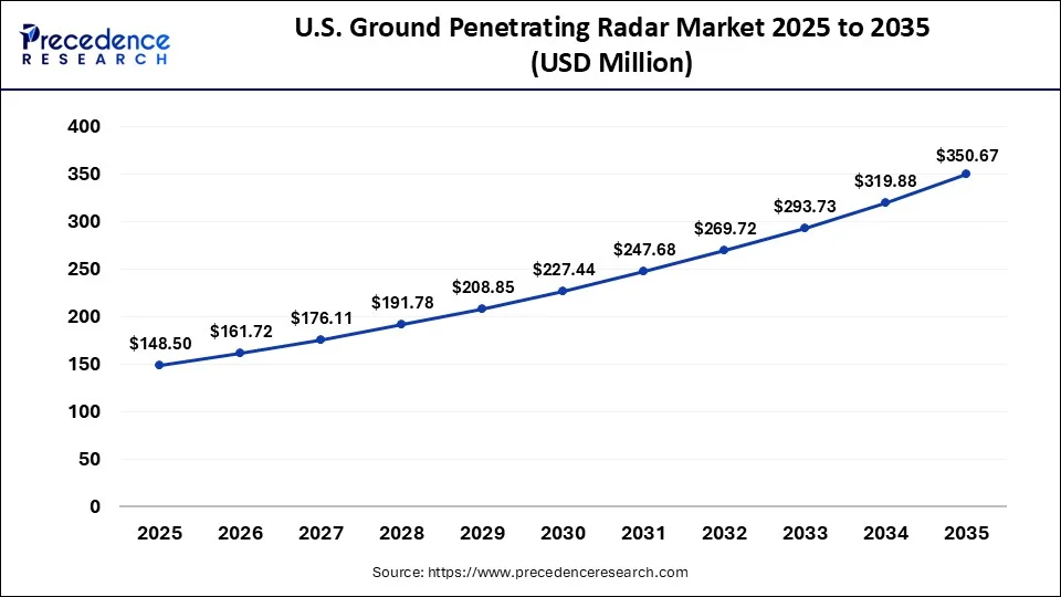
Extensive infrastructure modernization programs and transportation asset inspections continue driving widespread adoption of advanced ground penetrating radar technologies. Expanding mining exploration activities are increasing demand for ground penetrating radar in geological surveys and mineral resource investigations.
The Asia Pacific Is Expected to Grow at a CAGR of 12.7% From 2026 to 2035
Asia Pacific held the second-largest regional market share at 27% in 2026 and is expected to expand at a CAGR of 12.7% from 2026 to 2035, supported by accelerating urban development and expanding transportation infrastructure across major economies.
Accelerating urbanization and large-scale smart city investments are driving extensive deployment of ground penetrating radar technologies.
Massive investments in highways, metro rail projects, and urban infrastructure are increasing the need for accurate subsurface investigations.
Europe Held Significant Market Share of 28% in 2026
The Europe region held a 29% share of the market in 2026 and is expected to grow at a 9.10% CAGR between 2026 and 2035, driven by extensive investments in sustainable infrastructure rehabilitation and transportation network modernization.
Transportation modernization initiatives and industrial infrastructure inspections are strengthening demand for high-precision ground penetrating radar systems.
Rapid infrastructure digitization is expanding the use of ground penetrating radar for transportation asset management and lifecycle monitoring.
Latin America Held Notable Market Share with 5% in 2026
The Latin America region is expected to grow at a notable CAGR of 9.6% between 2026 and 2035, due to expanding investments in transportation upgrades, mining operations, and public utility modernization.
Strong mining activities and expanding transportation infrastructure projects are sustaining high demand for ground penetrating radar systems.
Rising geological exploration projects are creating new opportunities for advanced geophysical surveying technologies.
Middle East & Africa Held a Considerable Market Share of 4% in 2026
The Middle East & Africa region is expected to grow at a strong CAGR of 9.8% between 2026 and 2035, fuelled by increasing investments in urban infrastructure, energy projects, and transportation corridors.
Large-scale infrastructure megaprojects and smart city developments are significantly increasing demand for underground mapping technologies.
Expanding mining exploration activities are driving greater utilization of ground penetrating radar for geological investigations.
Ground Penetrating Radar Market Value Chain Analysis
- Supply Chain Structure
Manufacturers source antennas, RF components, processors, sensors, and positioning modules from specialized electronics suppliers before final system integration.
Key Players: Hexagon AB (Leica Geosystems), GSSI, Guideline Geo, Radiodetection, u-blox.
- Manufacturing Value Chain
Manufacturers design, assemble, calibrate, and test complete ground penetrating radar systems before commercial distribution.
Key Players: GSSI, IDS GeoRadar (Hexagon), Guideline Geo, MALÅ GeoScience, ImpulseRadar.
- Service Ecosystem
Engineering consultants, distributors, rental providers, and software firms deliver installation, training, maintenance, and data interpretation services.
Key Players: Fugro, AECOM, WSP, Tetra Tech, Seequent.
- Supply Chain Risks
Semiconductor shortages, electronic component disruptions, logistics delays, and skilled labor shortages affect production and equipment availability.
Key Players: Intel, Texas Instruments, Analog Devices, STMicroelectronics, NXP Semiconductors.
Competitive Landscape
Market Structure Analysis
The position of the GPR industry is a kind of happy medium. Between an established hardware-driven business and a rapidly changing software-driven business. The first commercial GPR company, GSSI, remains a benchmark company for newer companies. Built over 5 decades, durability benefits provide established manufacturers much more time to acquire a strong base. This may not be copied instantly by newer AI-based startups. But all the increased competition has been just in the software capabilities and not just the radar hardware. Grasping this three-layer model of hardware, software, and services is important to understand prior to directly comparing companies with one another.
Competitive Positioning Matrix
As technology and AI become more integrated, their success is increasingly isolating leading GPR vendors from the pack. In contrast to this relative trajectory, GSSI chooses a somewhat different processing technology, with an emphasis upon its proprietary HyperStackING processing technique for enhanced depth penetration and resolution in challenging soil types. The competitive landscape is completed by sensors & software and MALÅ, who have strong positions in geophysical and archaeological survey applications.
Market Share Analysis
Across a multitude of different companies within this industry. It is difficult to verify market share figures. This analysis does not contain unverified percentage claims. The only measure that can be determined with reliability is the relative competitive position in terms of scale, product variety, and institutional support. GSSI's 50 years of operation and OYO Corporation's assistance put it at an advantage in the field of hardware manufacturing. Its recent partnership integration with Topcon, announced in March 2026 at CONEXPO-CON/AGG in Las Vegas, only cements its leadership by adding related positioning and workflow markets to GSSI's fold.
Service-layer positioning conveys different competitive messages than that of the hardware business. All of GPRS' growth has occurred via continuity of acquisition. Resulting in the company becoming the largest private utility-locating and concrete-scanning company in the United States. Given that the service-layer leadership is semi-detached from the dynamics of the hardware market, in that GPRS deploys machines from various manufacturers. Rather than preferring a single brand, this creates a different kind of moat for the service-layer companies. That is one that's not based on proprietary technology but rather a trained workforce and national coverage.
Strategic Developments
Adopting a strategy of accelerating product launches and partnerships, visibility has increased significantly up to the first half of 2026. GSSI and Topcon Positioning Systems announced the integration of their GNSS-and-radar solutions. Together at CONEXPO-CON/AGG on March 3, 2026, by using GSSI's radar systems combined with Topcon's HiPer XR GNSS receiver and Collage Web workflow software. It is that partnership that enables users to address the sub-surface/spatial link gap. This provides customers with the opportunity to view sub-surface detection in the context of all data in a jobsite position.
Competitive Benchmarking
Service network and pricing strategy complete this picture of a benchmark. GSSI's depth of service has been established through its academy-based training infrastructure and decades of customers and product relationships. GPRS, on the other hand, has only one goal. That is competing in service network scale, with a wide national network of trained project managers to be found across purchased regional companies. The battle between service-network providers and software-centric rivals, and of hardware providers against service-network and software-agnostic providers. This is likely to be a key aspect of the overall competitive landscape in the GPR industry for the rest of this forecast period.
Ground Penetrating Radar Market Companies
- Radiodetection Ltd.
- Pipehawk Plc
- Israel Aerospace Industries Ltd
- IDS Georadar
- Guideline Geo
- Geoscanners
- Geophysical Survey Systems Inc.
- Chemring Group
- Raytheon Technologies Corporation
- Saab AB
- Thales Group
Strategic Growth Opportunities
High-growth Commercial Opportunities
Commercial opportunities in Australia, South Africa and Namibia are for ongoing mining exploration. They provide a good but more modest level of commercial opportunities. Drilling programs are expensive compared to the value of the data obtained, so firms are opting for radar to avoid them. Digital infrastructure is the enabling opportunity that connects all of these factors. Agencies are moving from requiring mapping to occur before excavation, to doing it at the planning and design stage, placing utilities in a GIS, and placing the results of that utility survey into a digital twin. GPR vendors who can provide the data directly into a GIS/digital twin end up capturing a greater share of the value than those who only sell a standalone report.
Technology Investment Opportunities
Autonomous inspection is just starting to become a frontier in the field of drone integration investments. Active-digit, or the ability to detect and plan the excavation while still in operation. This is being taken to a new level with RodRadar's Live Dig Radar, which has been embedded directly into excavator buckets and was granted an FCC Part 15 waiver back in 2026. Workers on high cost, long duration projects of tunneling and mining could benefit greatly from similar integrations with on-site robots to discard humans. These activities and still collect valuable data with continuous and uninterruptible monitoring. The technology from GIS, GPR and digital twin platforms is integrated the most competitive to create a competitive advantage, naturally, being where geographic expansion will focus first.
Geographic Expansion Opportunities
The Asia Pacific region presents the single biggest growth avenue. Given the current co-occurrence of metro expansion, smart city investments and nation-wide digital infrastructure initiatives. The magnitude of the underground construction booming the demand is exemplified from Mumbai itself. Where the work on the tunnel boring machines (TBMs) under construction for Metro Line 7A and twin tunnels for a Goregaon-Mulund Link Road is currently being completed through a section of one of the most congested districts of the city.
White Space Analysis
Perhaps the largest white space opportunity that isn't being used in the current GPR landscape is predictive infrastructure maintenance. Pococa is already moving from reactive repair to regular monitoring with the deployment of sensor networks and digital twins. Triggering alarms for a red flagging of degradation patterns that precede pipes explosions and cables failures. The predictive approach relies on essential baseline data. That baseline is generated using GPR, but few vendors currently offer that scanning service as an on-going monitoring subscription instead of a one-off deliverable upon completion of the survey. There are also further sectors that are not being served by the GPR, such as some small municipalities. That are unable to dedicate a member of their staff or purchase a GPR for their needs, as well as medium-sized mining companies by bigger vendors.
Future Outlook and Strategic Recommendations
Long-term Industry Outlook
Smart infrastructure monitoring is the next logical step in the course of automation and identification. GPR as a one-time surveying product into a continuous asset monitoring product. In its seventh annual report World Construction Today labeled comprehensive underground mapping as the solution to the digital dark age that exists beneath the majority of cities. Continuous monitoring with sensors is just a beginning to solve the issue. On the other hand, vendors with the ability to deliver data to these expanded digital asset management systems. They are likely to win the race against those continuing to deliver standalone spatial data from surveys.
Emerging Business Models
GPR-as-a-Service is proving to be a viable option. Tailoring the provision of GPR, as a service, to meet the varying requirements of hospitals. GPRS already has a version of this with its free SiteMap Personal subscription that's automatically included in each locate the company conducts. It provides a subscription service for clients. Delivering their subsurface data continuously as opposed to a one-off report. This enables them to refer to and share insights long after the initial survey on the field is finished.
Strategic Recommendations for Stakeholders
Rather than being an optional upgrade. Software and AI integration should be a key component of manufacturers' products. The fact that Proceq has decided to implement AI Auto Tagging instead of a tiered version indicates the level of competitive pressure. Furthering the adoption of automation as standard product requirements. On the other side, software providers should acknowledge that, as TerraScan AI and IDS GeoRadar's C-THRU platform have done. Doing business with a single hardware provider only becomes a barrier to software adoption, not an aid.
Ground Penetrating Radar Market Segments
By Product Type
- Handheld Ground Penetrating Radar
- Cart-based Ground Penetrating Radar
- Vehicle-mounted Ground Penetrating Radar
- Drone-mounted Ground Penetrating Radar
By Frequency Range
- Low Frequency (<250 MHz)
- Medium Frequency (250–1000 MHz)
- High Frequency (>1000 MHz)
By Component
- Control Unit
- Antenna
- Power Supply
- Display & Data Processing Unit
- Software
- Accessories
By Application
- Utility Detection
- Transportation Infrastructure Inspection
- Archaeology & Cultural Heritage
- Geology & Mining
- Environmental Assessment
- Concrete Inspection
- Military & Defense
- Forensic Investigation
- Others
By End User
- Construction & Infrastructure
- Oil & Gas
- Government Agencies
- Utility Service Providers
- Mining Companies
- Defense & Security
- Research & Academic Institutes
- Environmental Consulting Firms
- Others
By Survey Method
- Ground-coupled GPR
- Air-coupled GPR
By Distribution Channel
- Direct Sales
- Distributors & Dealers
- Rental & Leasing Services
By Region
- North America
- Latin America
- Europe
- Asia-Pacific
- Middle East and Africa
For inquiries regarding discounts, bulk purchases, or customization requests, please contact us at sales@precedenceresearch.com
Frequently Asked Questions





Ask For Sample
No cookie-cutter, only authentic analysis – take the 1st step to become a Precedence Research client
 Get a Sample




 sales@precedenceresearch.com
 Schedule a Meeting